The Three Rondavels: History, Myths & Interesting Facts
Towering above South Africa’s Blyde River Canyon, the Three Rondavels are among the most iconic natural landmarks on the Panorama Route, blending breathtaking geology with fascinating history and local folklore.
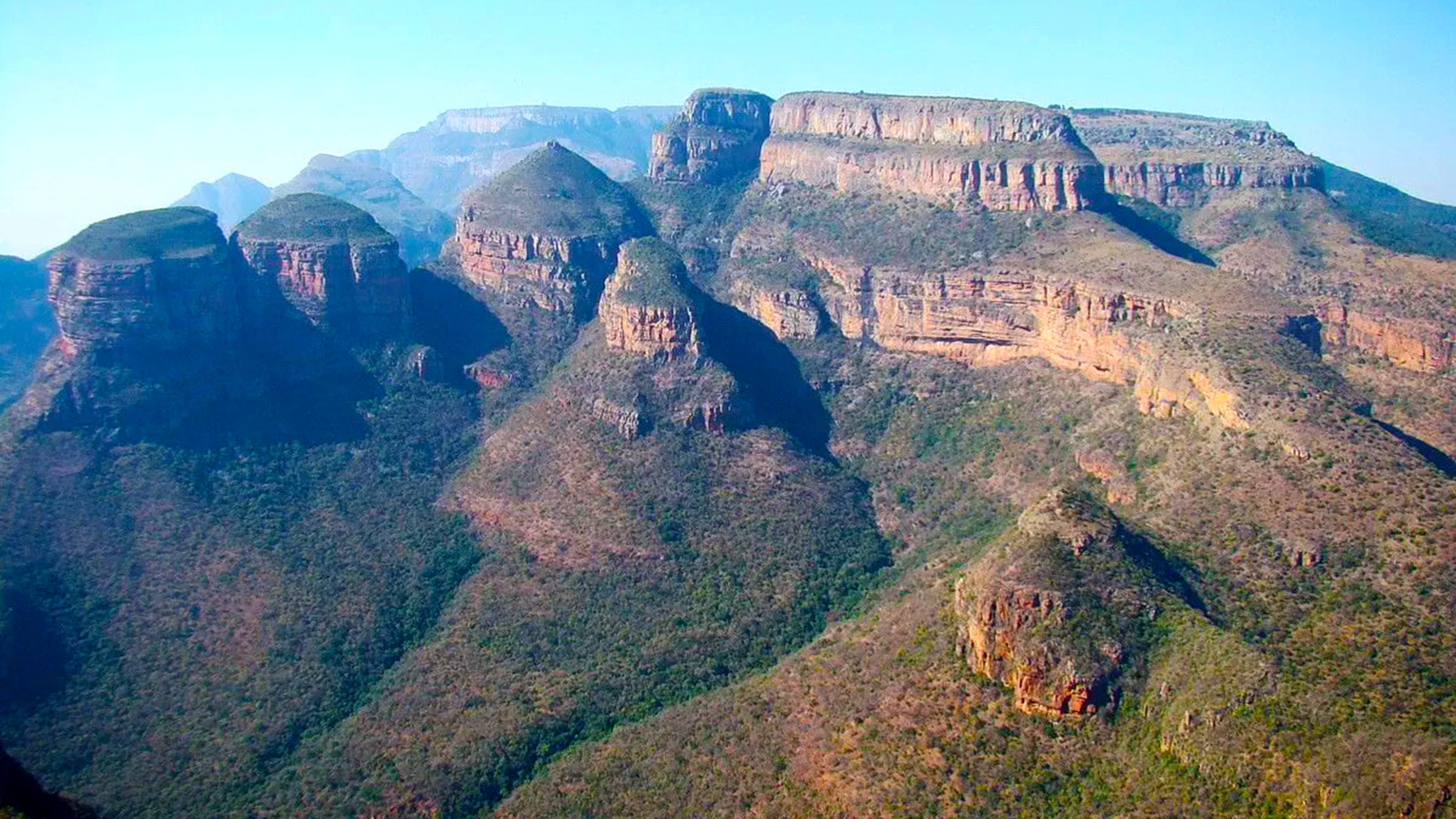
High above South Africa’s Blyde River Canyon in Mpumalanga, three towering, rounded mountains stand like timeworn sentinels. These iconic peaks are known as the Three Rondavels, named for their uncanny resemblance to traditional African rondavel huts – cylindrical, thatched-roof dwellings once common throughout the region. Rising nearly 700 metres above the surrounding lowlands, the Three Rondavels dominate one of the world’s largest canyons and offer spectacular views across lush valleys, dramatic cliffs, and winding rivers.
Early visitors often referred to the peaks as "The Three Sisters", but local tradition has given them a far more evocative identity rooted in regional history and legend. Standing at the Three Rondavels viewpoint, approximately 1,380 metres above sea level, visitors look out across a canyon carved by the Blyde River some 750 metres below. The landscape is widely considered one of the finest viewpoints in South Africa and remains one of the highlights of Mpumalanga’s famous Panorama Route.
As the afternoon sun sinks toward the horizon, the sandstone and quartzite cliffs glow in shades of amber and red, casting long shadows across the canyon floor. Yet beyond their astonishing beauty lies a deeper story—one of ancient geological forces, legendary chiefs, historic battles, and enduring folklore that continues to captivate visitors today.
Carved by Time: Geology & Formation
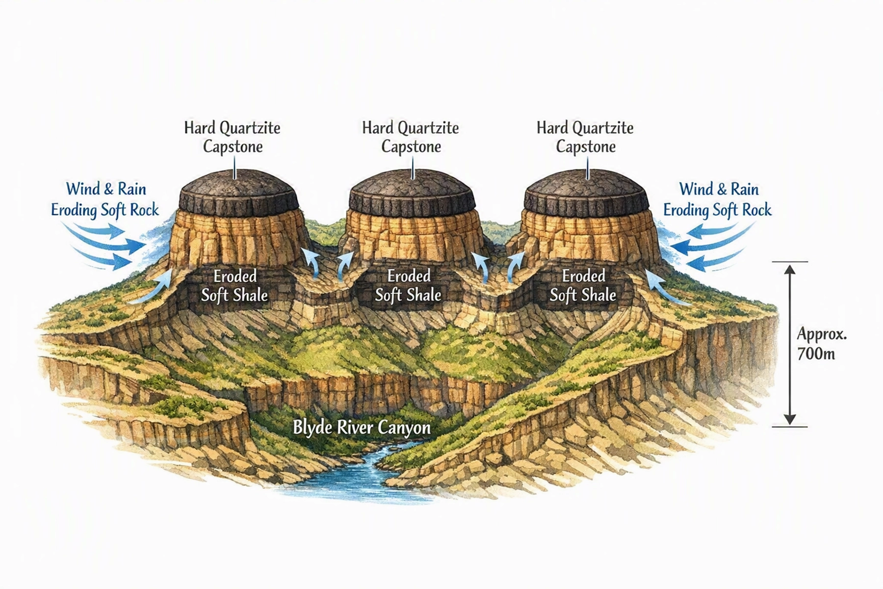
The Three Rondavels are often described as textbook examples of geological landforms shaped by erosion. These cylindrical buttes consist primarily of quartzite and shale and were formed over millions of years through the relentless actions of wind, rain, and flowing water.
Originally, harder quartzite layers protected softer shale beneath. Over vast periods of time, erosion wore away the weaker rock while the resistant caprock remained intact, preserving the towering columns below. This process ultimately created three free-standing pinnacles that rise approximately 700 metres above the surrounding landscape.
Their rounded summits and gently sloping sides give them the unmistakable appearance of giant rondavel huts. The dark quartzite capstones resemble traditional thatched roofs, making the resemblance even more striking. Today, they stand at the edge of the Drakensberg Escarpment as natural monuments overlooking the immense Blyde River Canyon.
Visitors can easily observe the canyon’s fascinating geological history. Distinct horizontal bands of reddish quartzite and lighter shale line the steep canyon walls, each layer representing a different chapter in the region’s ancient past. Far below, the Blyde River winds through the canyon before feeding into the shimmering Blyde Dam, creating a landscape that serves as a living lesson in geology and natural history.
Historical Roots: A Chief’s Victory in Stone
While geology explains the formation of the Three Rondavels, the mountains are equally significant as symbols of the region’s human history. Their story is closely connected to Chief Maripi Mashile of the Mapulana people, whose leadership helped shape the destiny of the area during the nineteenth century.
In 1864, during a period of conflict and migration known as the Mfecane, the expanding Swazi kingdom under King Mswati II launched an invasion into the region. Facing overwhelming odds, Chief Maripi united local Mapulana and Pedi warriors and retreated to the nearby mountain now known as Mariepskop.
Using the natural terrain as a fortress, Maripi's forces devised a brilliant defensive strategy. As Swazi warriors advanced through mist-covered mountain passes, defenders rolled massive boulders down the steep slopes, devastating the attacking forces. The resulting victory became legendary and is remembered as the Battle of Moholoholo or Mogologolo.
The defeat was so complete that tradition holds some surviving Swazi warriors remained in the region rather than returning home. Today, Mariepskop—standing 1,944 metres above sea level—bears the chief’s name as a lasting tribute to his leadership and military success.
The broad plateau adjacent to the Three Rondavels became known locally as Mapjaneng, meaning "the Chief," representing Maripi himself standing watch over the canyon. The three rounded peaks, however, carry an even more intriguing story rooted in local legend.
Myths & Legends: The Chief and His Three Wives
Local folklore tells that the Three Rondavels are the physical manifestations of Chief Maripi’s three wives. Their names are traditionally given as Magabolie, Mogoladikwe, and Maseroto.
Oral tradition describes the wives as spirited, independent, and occasionally quarrelsome. According to the legend, their constant disagreements eventually angered either the ancestors or the chief himself. As punishment, they were transformed into stone, creating the three towering peaks visible today.
While the story is clearly symbolic rather than historical, it remains deeply embedded in local culture. Some guides still delight visitors by suggesting that on particularly windy nights, the sounds echoing through the canyon are the voices of the three wives continuing their endless arguments across the valley.
This enduring folklore adds cultural depth to an already spectacular landscape. The Three Rondavels are viewed not merely as geological formations but as living symbols of the traditions, beliefs, and storytelling heritage of the people who have called this region home for generations.
Fascinating Facts About the Three Rondavels
An Ancient Panorama
The Three Rondavels are located within the Blyde River Canyon Nature Reserve, part of the world’s largest green canyon. The canyon stretches for approximately 26 kilometres and reaches depths of up to 750 metres. Its name, "Blyde," means "Happy" in Dutch, commemorating the joyful return of a group of Voortrekker explorers in 1844.
The Rondavel Shape
A rondavel is a traditional circular hut topped with a conical thatched roof. The Three Rondavels closely resemble these structures, with their domed summits and dark caprock creating the illusion of enormous stone huts sitting atop the canyon edge.
The Family of Peaks
The nearby plateau known as Mapjaneng represents Chief Maripi, while the three peaks themselves bear the names of his wives—Magabolie, Mogoladikwe, and Maseroto. These names continue to be used by local communities and tour guides today.
A Fortress in War
Mariepskop, towering behind the Three Rondavels, served as Chief Maripi’s defensive stronghold during the 1864 Battle of Moholoholo. Its steep slopes played a critical role in securing one of the most famous victories in regional history.
Wildlife & Natural Heritage
The area surrounding the Three Rondavels supports an impressive variety of wildlife. Visitors frequently encounter baboons around picnic areas, while agile klipspringers can sometimes be seen standing on rocky outcrops. Overhead, Cape vultures soar on rising thermals and African fish eagles call from the canyon below.
The surrounding Drakensberg Escarpment is rich in biodiversity and contains endemic plant species found nowhere else on Earth, including the rare Blyde River protea.
Where Nature and Legend Meet
The Three Rondavels represent far more than a spectacular viewpoint. They are a place where geology, history, and folklore converge to create one of South Africa’s most remarkable natural landmarks. Over millions of years, wind and water sculpted these distinctive peaks, while generations of local communities enriched them with stories of chiefs, battles, and legends.
Standing before these towering formations, visitors experience not only one of the most breathtaking panoramas on the Panorama Route but also a deeper connection to the cultural heritage of Mpumalanga. Every cliff, ridge, and summit tells a story—making the Three Rondavels a destination that inspires both awe and imagination.